


Cliffs of Moher
- from EUR 10
Sign up free — See who's going and message them.
About
More photos 11
1 / 11


Why go
- Cliffs that rise almost straight out of the sea and stretch for more than eight kilometres.
- Views of the Aran Islands, Galway Bay and the Twelve Bens in Connemara on clear days.
- Scenes from Star Wars Episode 7 shot here, among other film locations.
Opening hours
Today08:00 – 21:00Show all
Don't miss
- O'Brien's TowerA round stone tower built in 1835 by Sir Cornelius O'Brien as a lookout over the cliffs.Near the middle of the cliffs, reached by a path of about 200 m. On the map
- The highest point of the cliffsThe cliff face rises 214 metres above the Atlantic here.Just north of O'Brien's Tower. On the map
- The Atlantic Edge exhibitionInteractive displays on the geology, history, flora and fauna of the cliffs. The exhibition won an award from the Association of Heritage Interpretation.Inside the visitor centre, built into a hillside leading up to the cliffs. On the map
- Atlantic puffinsAtlantic puffins are the most notable birds here, nesting in large colonies.On isolated parts of the cliffs and on Goat Island, a small island nearby. On the map
History
The cliffs take their name from Mothar or Moher, an old promontory fort on Hag's Head. Since 2008 the area has been protected to preserve its wildlife, mainly seabirds. Since 2011 the cliffs have been part of the Burren and Cliffs of Moher Geopark, a UNESCO-recognised geotourism area. In the 1990s Clare County Council began work so that visitors could experience the cliffs with few man-made amenities. Protective works were built to shield the site from its many visitors, and many low stone walls were built on the site.
- 313–326 million years agoA river delta lays down the sand, silt and clay that become the shale and sandstone of the cliffs.
- 1808The old fort on Hag's Head is pulled down for stone to build a lookout tower meant to warn of invasion.
- 2007The visitor centre opens in February, after 17 years of planning and building, at a cost of €32 million.
- 2013The Cliffs Coastal Walk opens along the cliff edge; until then a barrier at the start of that path stopped walkers.
- 2019A student dies in a fall from the cliff top while trying to take a selfie. A warning sign is installed afterwards.
Show all
- 2024Visitors die in falls from the cliffs.
Tips for your visit
- Two cafés and several shops are in the visitor centre.
- Near the visitor centre the official path is set back from the edge; an unofficial path runs closer to it.
- An unsecured path also runs along the cliff edge to Hag's Head.
- The path of about 200 m to O'Brien's Tower is lined with stone slabs up to 1.40 m high, keeping visitors from the edge.
Best time to visit
- Late opening in July and much of August was introduced to spread out the peak crowds.
- The cliff face is best lit by the westering sun, so come late in the day.
- Admission is cheaper in the morning.
- At peak season about 30,000 birds of more than 20 species live on the cliffs.
Know before you go
- Open every day from 08:00 to 21:00, with longer hours in July and much of August.
- The entry charge covers parking, the visitor centre and viewing from O'Brien's Tower.
- The Cliffs Coastal Walk was closed in February 2025 for safety reasons and was still closed in September 2025. Its current status is not confirmed.
- The Cliff Walk outside the official facilities was closed in July 2016 over the risk of rock falls.
How to get there
- CarThe address is Lislorkan North, Liscannor.
- CarLiscannor lies about 6 km south of the cliffs and Doolin about 7 km north.
- BusBus Éireann route 350 links the cliffs with Ennis, Ennistymon, Doolin, Lisdoonvarna, Kinvara and Galway.
- BusA privately operated shuttle bus serves the site from Doolin.
- ParkingThe car park is near O'Brien's Tower.
Accessibility
- Paved paths The visitor centre has paved paths.
Shorts
-
 Cliffs of Moher, Irelandcalebxixi
-
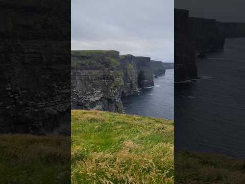 Cliffs of MoherPiT [K]
-
 View of Liscannor and Lahinch and beyond from the Cliffs of MoherPhil Shannon
-
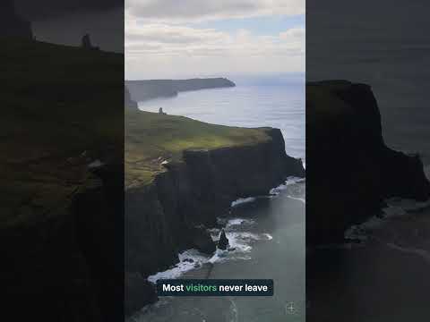 Cliffs of Moher: 214m straight down — and the quiet path most missCeltic explorer
-
 Cliffs of Moher Experience Tips and Tricks!Hannah's Good Travels
-
 The Magic of the Cliffs of MoherTODAY
-
 Double rainbow at the cliffs of moherGowing Guide
-
 This is why people die out here 😳 Cliffs of Moher!Bryan and Amanda
Interesting facts6
-

Branaunmore, a 67-metre sea stack below O'Brien's Tower, was once joined to the cliffs.
Cliffs of Moher - Wikipedia -

In the local language the name Aillte an Mhothair means 'cliffs of the ruins'.
Falaises de Moher - Wikipedia -
 2022
About 41% of the 1.1 million visitors in 2022 came from the United States.
Cliffs of Moher - Wikipedia -

One scene of the sixth Harry Potter film was shot here.
Falaises de Moher - Wikipedia -

The cover of the Kelly Family album Over The Hump was shot here.
Cliffs of Moher - Wikipedia -

They are the best-known cliffs in Ireland but not the highest.
Cliffs of Moher - Wikipedia
Sources: Cliffs of Moher - Wikipedia · Doolin - Wikivoyage (see) · Cliffs of Moher - Wikipedia · Falaises de Moher - Wikipedia · checked 17 Oct 2026
Plan from here: Evening walk →
Questions and answers
Where are the Cliffs of Moher?
The Cliffs of Moher stand on the west coast of County Clare, between Doolin and Liscannor, on the southwestern edge of the Burren. Liscannor lies about 6 km to the south and Doolin about 7 km to the north.
Can you see the Cliffs of Moher from the sea or from the air?
Yes. Separate ferry trips let visitors view the cliffs from sea level. Aircraft from Connemara Airport also offer a view of them at certain times.
Are the Cliffs of Moher part of a UNESCO geotourism area?
Yes. The cliffs have been part of the Burren and Cliffs of Moher Geopark since 2011. UNESCO recognises the geopark as a geotourism area.
How high are the Cliffs of Moher?
The cliffs reach 214 metres above the Atlantic just north of O'Brien's Tower. At Hag's Head, at the southern end, they rise about 120 metres.
Where are the main viewing areas on the Cliffs of Moher?
Three main viewing areas are spread along the cliffs. O'Brien's Tower stands near the middle, and the visitor centre is built into a hillside leading up to the cliffs.
- See who's going — faces, not ticket counts.
- Write to someone who shares your interests — no swipes, no matches, no paywall.
- Pick the event or the place to meet at — and go together.