
Southbank
Sign up free — See who's going and message them.
About
Why go
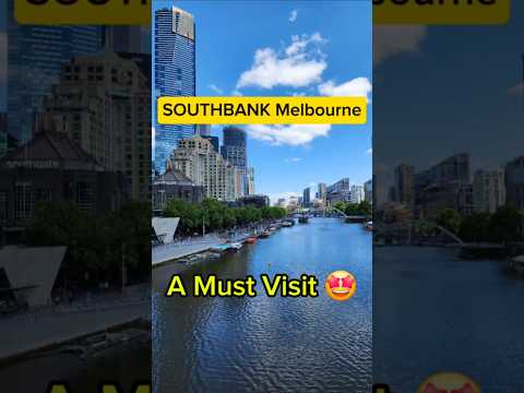
- Southbank Promenade runs from Princes Bridge to Queens Bridge Street and Queens Bridge, then west beneath King Street Bridge to Spencer Street Bridge.
- Southbank Promenade and Southgate form a riverside entertainment district extending to Crown Casino.
- Ophelia, a sculpture by Deborah Halpern, is in the Southgate precinct.
Don't miss
- Eureka TowerA 91-floor residential tower built between 2002 and 2006.Southbank
- Malthouse TheatreThe theatre opened in a former malt house in the late 1980s.City Road
Tips for your visit
- The arts and crafts market is on Southbank Promenade near the Arts Centre every Sunday.
- Southbank Promenade is part of the Capital City Bicycle Trail. Cyclists must keep to 10 km/h because of pedestrian traffic.
Interesting facts3
Shorts


History
Before European settlement, the area was a low-lying swamp inhabited by Aboriginal tribes. The railway, bridge and cultural venues followed as Southbank developed from an industrial area into a district of apartments and offices. The riverfront changed through the opening of the Evan Walker Footbridge and Southbank Promenade, followed by developments along the Yarra.
- 1854The Port Melbourne railway crossed the area; swamps were filled and industrial development began.
- 1890Queensbridge opened a route to City Road and allowed cable trams to reach Port Melbourne.
- 1968The National Gallery of Victoria opened in Southbank.
- Early 1980sThe Arts Centre opened in Southbank.
- 1987The former Port Melbourne railway line became light rail, running along Clarendon Street into the city.
Show all
- 1990The Evan Walker Footbridge and Southbank Promenade opened as projects to reconnect the city with the Yarra.
- Early 1990sSouthbank shifted from a mostly industrial area to a district of apartments and offices.
- 1996The Melbourne Convention & Exhibition Centre was developed along the Yarra.
- 1997Crown Casino was developed along the Yarra.
How to get there
- TramTram route 1 runs along Sturt Street in Southbank.
- TramTram route 58 runs via Queensbridge Street and Kings Way.
- TramTram route 96 runs via Clarendon Street and Whiteman Street.
- On footSandridge Bridge links Southbank to Flinders Street railway station as a pedestrian and cycle path.
- CarKingsway, Clarendon Street and Queensbridge/Moray Street are main north–south roads into the city centre; City Road is a main east–west route through Southbank.
Sources: Southbank, Victoria - Wikipedia · checked 1 Oct 2026
Questions and answers
Can I cycle along Southbank Promenade?
It forms part of the Capital City Bicycle Trail. Cyclists must keep to 10 km/h because of pedestrian traffic.
Which roads connect Southbank with Melbourne’s city centre?
Kingsway, Clarendon Street and Queensbridge/Moray Street are the main north–south roads into the city centre.
What is Southbank’s main east–west road?
City Road is a main east–west route through Southbank.
Which apartment towers shape Southbank’s skyline?
Southbank has a large cluster of apartment towers, including Australia 108 and Eureka Tower.
- See who's going — faces, not ticket counts.
- Write to someone who shares your interests — no swipes, no matches, no paywall.
- Pick the event or the place to meet at — and go together.